A blog of the Africa Program
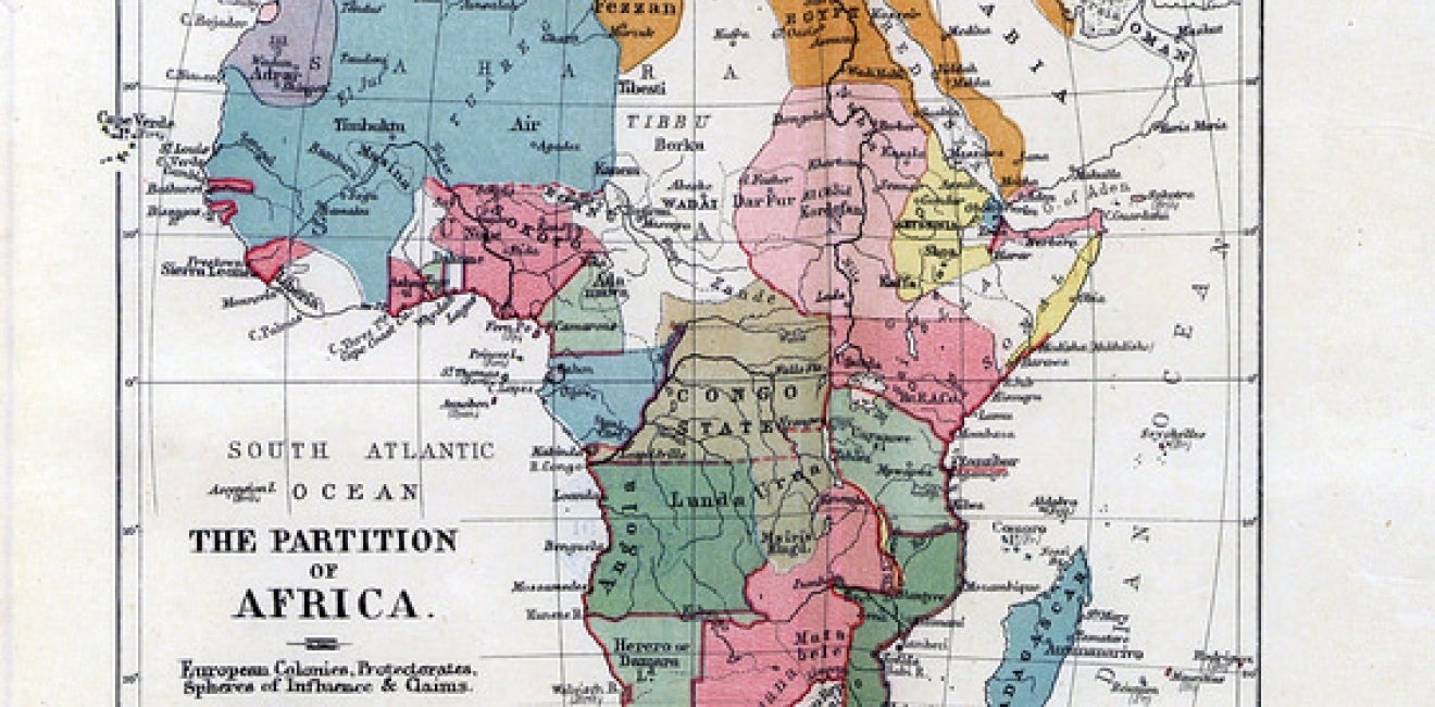
Pictured here is a map of the Partition of Africa. Photo courtesy of Stuart Rankin via Flickr Commons.
The Scramble for Africa began with the Berlin Conference (1884–85) and ended by the early twentieth century. During this period, European colonizers partitioned Africa into spheres of influence, colonies, and various segments. They partitioned land from European capitals, with limited knowledge of the geography, history, and ethnic composition of Africa. In many African countries, a significant portion of their population belongs to groups split by colonial partitions.
During the onset of colonization, European powers preferentially dealt with African local leaders and chieftaincies. Colonial powers employed underhand mechanisms in territorial acquisition and boundary making such as deceit, fraud, intimidation, and bribery. Moreover, colonial powers utilized various techniques to influence African leaders and obtain resource rich land.[1]
The Berlin Conference legitimized the partition of Africa; colonizers designed regional maps without providing any notification to the local African rulers, and made treaties among colonial powers to avoid resource competition. However, many errors were made due to their superficial knowledge of the continent and undeveloped maps in existence. Lord Salisbury, the British Prime Minister in 1906, demonstrated this arbitrary and under-informed approach at the signing of the Anglo-French convention on the Nigeria-Niger boundary in 1906, when he said: "We [the British and the French] have been engaged in drawing lines upon maps where no white man's foot ever trod: we have been giving away mountains and rivers and lakes to each other, only hindered by the small impediments that we never knew exactly where the mountains and rivers and lakes were."[2] This statement helps us to understand how colonial powers designed artificial African boundaries without knowledge of the land and local communities.
European powers completed cartographic surveys of territories through boundary commissions from 1900-1930, which allowed for total control of colonies. However, these surveys focused solely on land control and disregarded the impacts of partitioning on ethnic groups. Artificial borders split many closely related ethnic groups into different colonial regions. In the Horn of Africa, for instance, they split Somalis into French Somaliland, British Somalia, Italian Somalia, Ethiopian Somalia, and the Somali region of northern Kenya. Such colonial borders had massive effects on the Somali people, who share a common culture, way of life, and religion, but live as separate citizens of Ethiopia, Djibouti, and Kenya. Similarly, the Afar people of Ethiopia were split amongst Ethiopia, Eritrea, and Djibouti, and the Anyuaa and Nuer were split between Ethiopia and South Sudan.
Following artificial border designs, African communities could not move freely in their daily activities and nomadic practices, which inflicted economic hardship and social inconvenience. Changing the lifestyle and structural systems of African communities negatively affected their traditional life, administrative structures, and economic well-being. This deprived African borderland communities of economic opportunity by hindering their movements, and forcing them to live differently than their traditional life. For example, many Africans are pastoralist and nomadic people that need vast land for grazing and water. However, artificial borders limited borderland people to herding on limited land and forced them into resource competition and confrontation due to limited mobility with other borderland peoples.
Besides improperly designed borders, European colonial powers employed "divide and rule," "direct rule," and "assimilation" policies, which forced the loss of social norms, identity, and social order among Africans. Moreover, these policies instigated conflicts among local people, dividing them even further and consequently strengthening colonial power. Doing so helped gradually develop hostile relations among borderland people, and post-independent African governments and political elites used this division for political means.
Some political elites in Africa affiliate more along ethnic lines, and play crucial roles in fueling tensions and escalating political disenfranchisement. For instance, the Lou-Nuer of South Sudan and the Jikany-Nuer of Ethiopia are the same ethnic group, and live along the Ethiopia-South Sudan border, yet they are considered as two distinct ethnic groups with different nationalities and have developed hostility through resource competition.
Despite the effects of colonization and artificial borders on borderland communities, African political leaders have not alleviated these problems but rather used them as political instruments. Improper border design and the partitioning of ethnic groups have contributed to underdevelopment and instability in African states. In addition, the disconnect between center-periphery relations demonstrated by the exclusion of borderland communities in economic development exacerbates the challenges.
The lack of economic, social, and political development and limited upward mobility expose borderland communities to a number of problems, including widespread poverty, lack of infrastructure, limited education, and cross-border conflicts. The improper design of African borders and use of these designs as political instruments have increased instability and underdevelopment for borderland communities across the continent.
Tasew Gashaw is a former Southern Voices Scholar Network for Peacebuilding scholar.
[1] Jeffrey Herbst, "The Creation and Maintenance of National Boundaries in Africa," (International Organization, 43, no. 4, 1989), 673-92. [2] Lord Salisbury quoted in Anene, J.C, The International Boundaries of Nigeria, 1885-1960 (London, The Framework of an Emergent African Nation, Longman Press, 1970), 3.
Author

PhD Candidate, Addis Ababa University; Institute for Peace and Security Studies

Africa Program
The Africa Program works to address the most critical issues facing Africa and US-Africa relations, build mutually beneficial US-Africa relations, and enhance knowledge and understanding about Africa in the United States. The Program achieves its mission through in-depth research and analyses, public discussion, working groups, and briefings that bring together policymakers, practitioners, and subject matter experts to analyze and offer practical options for tackling key challenges in Africa and in US-Africa relations. Read more

Explore More in Africa Up Close
Browse Africa Up Close
The Innovative Landscape of African Sovereign Wealth Funds
