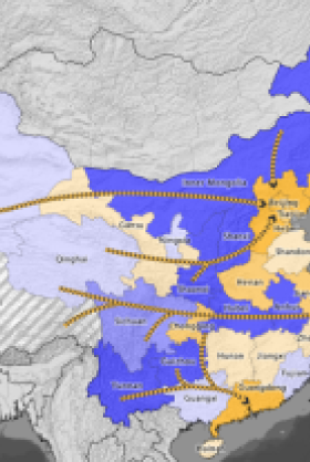
INTERACTIVE: China’s West-East Electricity Transfer Project


The Wilson Center’s China Environment Forum is proud to announce that we are launching our first interactive infographic: a map of China’s West-East Electricity Transfer Project. The map underscores China’s energy and water imbalances and the looming choke point China faces in terms of water, food, and energy security. The map also illustrates how consumer goods made in China’s factories along its eastern coast are powered by coal and hydropower in the country’s western provinces.
Feeding the Beasts
Mammoth infrastructure development is keeping China’s economic engine running at a fast clip. Nevertheless, China’s urban and industrial centers on the east coast still face energy shortages, in large part because most wind, coal, and hydro power plants are concentrated in the country’s inland provinces. China’s northern grain belt also faces water shortages as increasing coal production uses more and more water.
Instead of addressing the sources of these water and energy imbalances through conservation and other demand management techniques, China’s policymakers are “feeding the beasts” by undertaking two huge infrastructure projects.
The first is the South-North Water Transfer Project, the largest infrastructure project in the world, which will eventually transfer 35 billion cubic meters of water every year from China’s wet south to its dry north.
The second is the West-East Electricity Transfer Project. Initiated during the 10th five-year plan (2000 to 2005), the project is designed to bring investment and development to China’s lagging west while satisfying the growing electricity needs of the country’s eastern provinces.
The project’s first phase has been and is continuing to expand the western provinces’ electricity-generating capacity, primarily through the construction of new coal bases and hydroelectric dams. The second ongoing component is the construction of three electricity-transmission corridors that connect newly built generation capacity in the north, central, and south to the coast (see arrows on map).
China's West-East Electricity Transfer Project. Click the map to learn more.
Each of the corridors is expected to exceed 40 gigawatts in capacity by 2020 – a combined capacity equivalent to 60 Hoover Dams. The seven recipient provinces – Beijing, Tianjin, Hebei, Shanghai, Zhejiang, Jiangsu, and Guangdong – together consume nearly 40 percent of China’s total electricity.
Yunnan’s Nuozhadu Dam on the Mekong River was constructed as a part of this project, and has been touted as part of the backbone of the southern corridor, sending two-thirds of its output to Guangdong – the leading province in export manufacturing.
The controversial Three Gorges Dam is an integral component in the central corridor, sending 35 percent of its electricity to the Yangtze River Delta – China’s second largest manufacturing region, behind Guangdong. The southern corridor also receives energy from the Three Gorges Dam, albeit only about 16 percent of the dam’s output.
Also along the central corridor, the longest, single ultra-high voltage direct current line in the world connects the Xiangjiaba dam on the Yangtze River (between Yunnan and Sichuan provinces) to Shanghai. It is 1,287 miles long and has a capacity of 6.4 gigawatts.
“Made Possible by Coal and Water”
Though the West-East Project brings energy security to the east coast, it exacerbates water and food insecurity in the fragile ecosystems of the west. Because China’s eastern economic powerhouse provinces rely on western-made electricity, the energy sectors in the west take priority over local residential and agricultural water users.
These conflicting demands are creating vulnerabilities – or choke points – that China must address to sustain its current growth.
For example, in addition to providing hydroelectric power to Guangdong and elsewhere, Yunnan’s rivers are being diverted north as part of the South-North Water Transfer Project. But the region is now three years into a serious drought. This creates tension between local agricultural needs and those of Yunnan’s dependents, and if the south and the north experience drought at the same time and Guangdong province is still demanding power from Yunnan, the situation could potentially be much worse.
In fact, Yunnan’s drought has already had impacts in Guangdong. In the summer of 2011, factories in Guangdong province were asked to cut power at different hours of the day for varying lengths of time because dams in Guizhou, Guangxi, and Yunnan were producing electricity far below capacity – some as low as 10 percent of normal daily output. In total, during early 2012, reserve hydropower capacity in the three provinces of the southern corridor was down 47 percent year-over-year, thanks to the ongoing drought.
But perhaps even more troubling, the West-East Electricity Transfer Project illustrates how the Western world is driving the increasing use of coal and hydropower in China. Indeed, much of the electricity produced from coal and hydropower in western China is transmitted across the country to factories making cheap goods for Western customers. It seems that in addition to “made in China,” most of our consumer goods should perhaps say, “made possible by coal and water.”
Tyler Gibson is a research assistant for the Wilson Center’s China Environment Forum. This map was created by Gibson and James Conkling, fellow at Amnesty International. Special thanks to Zifei Yang for her help in finding the data, and Jennifer Turner, Susan Shifflett, Aubrey Parker, and Katie Beck for their valuable input.

China’s global footprint isn’t just an economic one, it’s an environmental one. From BRI investments in Africa and Asia to its growing presence in Latin America, understanding China’s motivations, who stands to gain - and who stands to lose - is critical to informing smart US foreign policy. Read more


The Environmental Change and Security Program (ECSP) explores the connections between environmental change, health, and population dynamics and their links to conflict, human insecurity, and foreign policy. Read more


